Trails developed
by passionate trail-RUNNERS
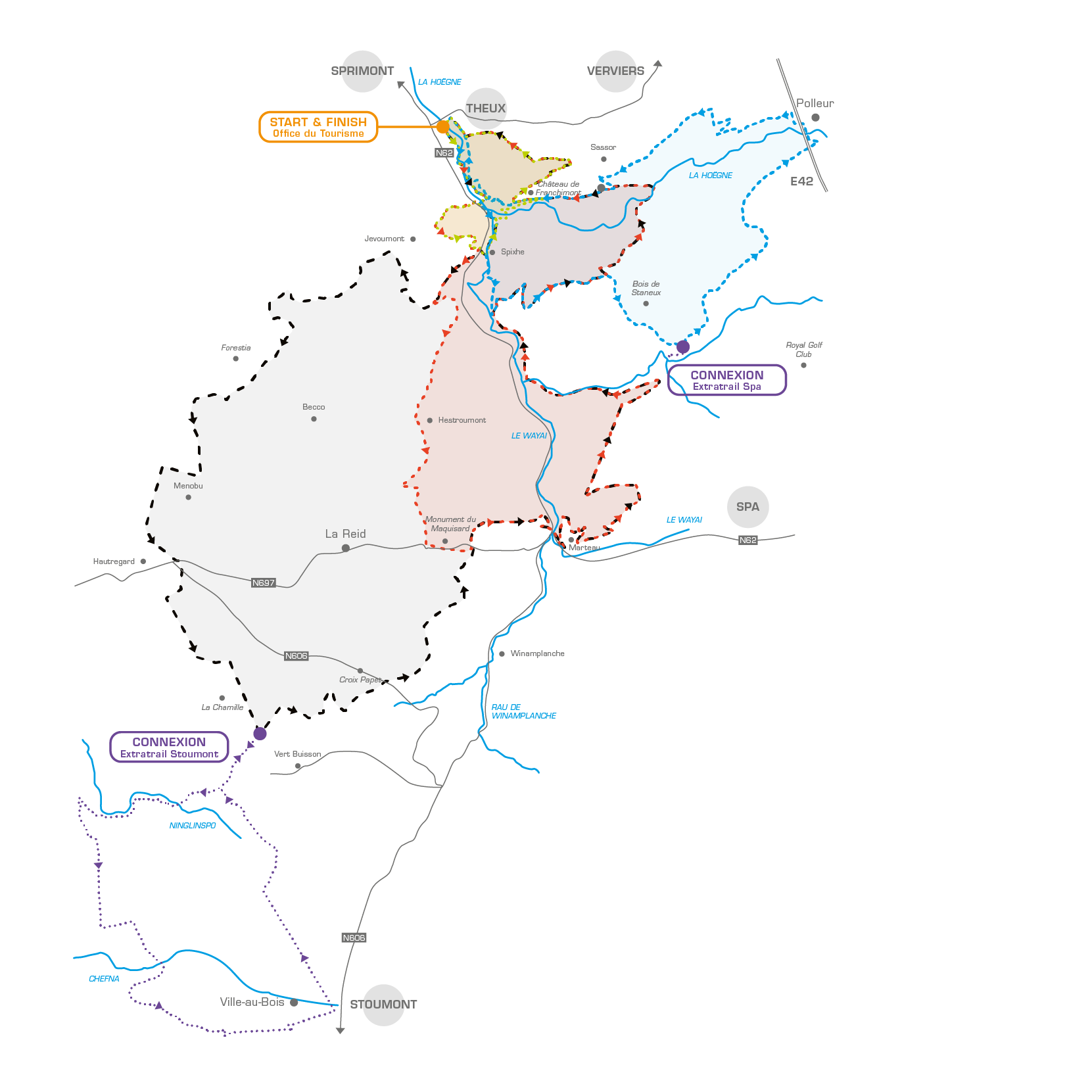
The ExtraTrail concept is now in place in the commune of THEUX. The 8, 18, 26 and 37 km routes of THEUX and connections to Spa and Stoumont are fully operational since 2017.
IMPORTANT INFORMATION
You can run freely. The use of the trails is the responsibility of the individual. ExtraTrail cannot be held liable for any damage or injuries caused to users of our trails.
Some structures (bridges or duckboards) or very technical paths are not designed to be traversed at speed; ExtraTrail encourages trail runners and Nordic walkers to approach these sections with caution and not to run.
No compensation can be claimed from ASBL ExtraTrail, the owner of the site or the infrastructure manager in case of an incident or accident occurring to a user of these structures present along our routes.
In areas frequented by walkers and families, we highly recommend being friendly and courteous so that everyone can enjoy these often unique spots.
This website gives precise indications of the routes, the state of the paths, precautions to be taken, a weather update, practical information and closures in case of a storm warning or hunts.

ExtraTrail Theux
Green trail
Town center
Blue trail
Town center
Red trail
Town center
Black trail
Town center
Connection Theux - Spa
Connection Theux - Stoumont
Connection Theux-Stoumont-Theux
GOOD TO KNOW
Created with the help of the local trail runners club « Les Boitheux », all Theux routes have been carefully designed to offer a variety of landscapes and a range of technical difficulties. These routes have been digitalised using the « Sity Trail » platform. On the ground, the routes are marked by easily identifiable permanent markers.
The 4 Theux trails (green 8 km, blue 18 km, red 26 and black 37 km) start in the town centre, close to the Syndicat d’initiatives (Rue du Pont 3 - 4910 Theux – GoogleMap), via Place Pascal Taskin then Rue de la Hoëgne.
The Theux Trail
NATURE & TRADITION

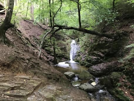
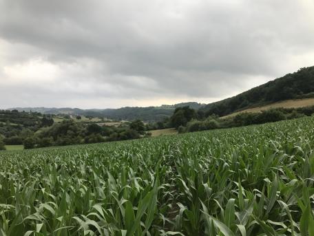
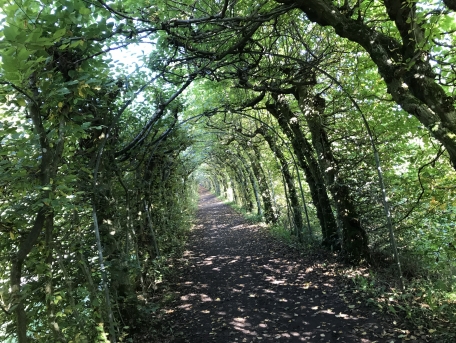
Theux is the perfect combination of a long history dating back to antiquity and a specific and generous natural environment.
Located in a green oasis, this small town at an altitude of 220 m has been developed over the centuries on the banks of the Hoëgne, bordered to the north-west by the High Fens and to the south by the Herve plateau.
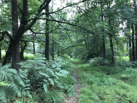
Theux also has a large community of dedicated and committed trail runners who don’t fear distance or elevation. They roam the hilly tracks and paths, pass through the forests along the rivers while enjoying panoramas from a very specific geological phenomenon called the “window of Theux.”
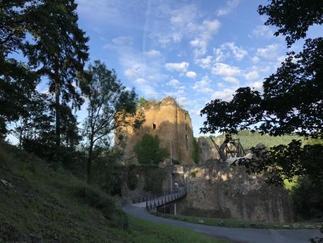
The Theux trails cover both sides of the Hoëgne Valley. They extend from the Bois de Staneux to the Bronromme fens, via Château de Franchimont, the Forrestier wildlife park as well as Carville de Vert Buisson.


Comment
Wed, 07/05/2017 - 11:14
Sat, 07/15/2017 - 15:56
Sat, 07/15/2017 - 22:21
Thu, 07/27/2017 - 11:42
Sat, 08/05/2017 - 16:58
Mon, 08/07/2017 - 07:14
Sat, 10/14/2017 - 15:00
Mon, 10/16/2017 - 07:08
Thu, 12/27/2018 - 08:55
Thu, 12/27/2018 - 10:56
Tue, 08/15/2017 - 07:30
Wed, 08/16/2017 - 07:40
Sat, 08/19/2017 - 06:23
Sun, 08/20/2017 - 19:57
Wed, 08/23/2017 - 20:22
Thu, 08/24/2017 - 07:55
Sat, 08/26/2017 - 20:39
Sun, 08/27/2017 - 17:16
Sun, 09/03/2017 - 13:27
Sun, 09/03/2017 - 13:31
Sat, 09/09/2017 - 11:34
Sat, 09/09/2017 - 12:27
Sun, 10/15/2017 - 17:56
Mon, 10/16/2017 - 07:07
Sun, 11/05/2017 - 23:44
Sat, 12/02/2017 - 18:32
Sat, 12/02/2017 - 18:42
Mon, 12/04/2017 - 11:59
Mon, 12/04/2017 - 12:20
Mon, 02/26/2018 - 09:27
Mon, 02/26/2018 - 09:56
Fri, 03/02/2018 - 10:02
Fri, 03/02/2018 - 10:24
Sun, 04/15/2018 - 12:40
Sun, 04/15/2018 - 16:49
Sun, 06/03/2018 - 07:36
Sun, 06/03/2018 - 09:16
Sat, 03/02/2019 - 13:27
Sun, 03/03/2019 - 09:52
Sun, 05/05/2019 - 20:52
Tue, 05/14/2019 - 18:59
Wed, 05/15/2019 - 07:46
Sat, 07/27/2019 - 18:15
Sun, 07/28/2019 - 10:52
Sat, 08/17/2019 - 16:35
Sun, 08/18/2019 - 08:48
Mon, 08/26/2019 - 10:37
Mon, 08/26/2019 - 13:32
Sun, 03/01/2020 - 14:33
Sun, 03/01/2020 - 17:34
Sat, 12/23/2017 - 19:43
Wed, 02/12/2020 - 19:26
Wed, 02/12/2020 - 19:48