Description of the trail
A: Town centre (Malmundarium - Tourist Office)
B: Lake Robertville dam
A connection with the Jalhay Extratrail (Jalhay extratrail route) is possible from the Croix des Fiancés (Fagne de la Polleur) and from Vecquée. The latter will allow you to discover the wonders of the Hoëgne before leading you to the typical and very pretty village of Sart.
Practical guide
and tips
Following a route that shares a starting point with the red trail, start at the Malmundarium (town centre) passing in front of the porch of Saint Pierre Cathedral which you should skirt around to reach the Calvaire path. The single track road takes you to Livremont then you ascend to Belvédère.
Then take the path which undulates over the contour line until you reach a fork at KM 2.1. Turn to the right at a right angle and begin a steep climb towards Jacob’s Cross. Once you have reached the cross, keep right to take the small asphalt road leading to the hamlet of Chôdes. At KM 3.5, turn left and enjoy the breathtaking view of the Warche valley and its small tributaries.
As you begin your descent, leave the red trail on your left to tighten to the right and make a wide loop in a coniferous massif. The negative elevation you are enjoying will soon be compensated for by a beautiful climb along a stone path above which you will take a sharp left turn. At KM 7.5, a short section of paved road will allow you to join a magnificent single track road overhanging the ridge overlooking the Warche Valley. Pure happiness. But watch where you are putting your feet. You risk going flying while distracted by the breathtaking view of the watercourse winding below.
Stay in this single track road until you reach the Lake Robertville dam (departure B). For runners with vertigo, cross the dam on the right-hand side (water side). For everyone else, a quick glance to your left will allow you to appreciate the depth of the Warche valley.
Just after the dam, turn left to reach Reinhardstein Castle. Stop your watch and take the time to admire the medieval building whose origins date back to 1354. Restored in the late 1960s, the castle now houses a museum and can be hired for private events.
Continue along the opposite side before walking below the castle to follow the right bank of the Warche. The small path takes you to the confluence with the Bayehon (stream), which you discover just after the lakes and the Moulin de Bayehon (brasserie). Note that this section is shared with the red route.
Less than a kilometre after crossing the road (beware of the traffic), leave the red route that continues climbing to Bayehon and head to the right to discover another stream: the Ghaster.
At KM 17, a zig-zag requires you to go up part of the Ovifat ski slope. Regularly covered in snow in the winter, alpine skiing is possible here while fun activities are organised in the summer.
While you follow a contour line towards the Nature Centre of Botrange, just before KM 19, the idea of a break at the Brasserie Peak Beer seems appealing. Famous for being the brewery at the highest altitude in Belgium, you only need to stray a few metres from the path to discover this lovely little business offering the chance to enjoy the fruits of their labours in moderation.
Just after the Nature Centre of Botrange, cross the road to follow the beautiful Walloon Fagne for a kilometre and a half. The view is quite simply incredible. Not surprising since you have reached the country's peak: 694 metres! A selfie and a few souvenir photos are a must.
Once you have crossed Route de la Baraque Michel, you will reach one of the highlights of this black trail: the path along the Polleur stream, overhanging the edge of the fens of the same name. The technical and hilly path gives you a unique panorama of a few square kilometres of wilderness. By leaving the single track road by a small pavilion reserved for walkers (KM 25), you will discover the connection with the red Jalhay route.
Leaving the connection on your right, climb to the left along a small tarmacked road to reach a very boggy firebreak. Be careful not to lose your footing. Many runners have become stuck in the bog up to their knees.
A long grassy firebreak particularly exposed to the wind and the sun (when there is any) takes you to a wooded area full of roots. This area is also very humid. By chance, just a little further down, you will reach the duckboards that will take you to the hills of the Trôs Marets, another gem along the Malmedy route. It is here that you will again meet the red trail that you will leave to your left just after crossing Route de l'Ancienne Douane between Hockai and Mont-Xhoffraix.
You leave the bed of the Trôs Marets to reach Ferme Libert (restaurant) and the Bike Park. After having passed the mountain bike track, you will reach the green trail by the chapel to climb again to reach a lovely single track road through the meadows and forest bordering Bernister. Follow a wider stone path that takes you to Outrelepont, an old district of Malmedy built on the banks of the Warche. Once you’ve passed the old bridge, you can declare yourself victorious. Your departure point is just 300 metres away. You can now enjoy a Bellvaux beer or the Malmedy Baisers !
Advice
Food and drinks required.
Mobile phone required.
Survival blanket and whistle recommended.
This route is very technical: roots and stones may be extremely slippery in case of humidity.
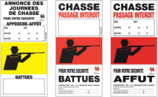
The route crosses part of the Fagne. Climatic conditions may be very changeable. Never leave the marked route, especially during fog or snow.
Check the accessibility of the Hautes Fagnes Nature Reserve.